
Jomo Kenyatta International Airport (JKIA) features a central circular design that optimizes passenger movement and access to facilities. This configuration includes the main terminals 1A, 1B, 1C, 1D, and 1E, strategically positioned around a central hub to facilitate efficient transit and minimize walking distances.

The circular layout ensures that passengers can easily navigate between terminals, enhancing the overall travel experience. Additionally, the terminals are designed with close proximity to the runways, allowing for quick access and reduced taxiing times for aircraft. This thoughtful design not only boosts operational efficiency but also improves passenger convenience, making JKIA a key aviation hub in East Africa.
Google Maps Location of JKIA in Nairobi.
JKIA Terminal Overview Map
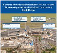
This map provides a detailed aerial view of Jomo Kenyatta International Airport (JKIA) in Nairobi, Kenya.
It shows the layout of the four main terminals, 1A, 1B, 1C, and 1D, with labels indicating their specific purposes such as arrivals, departures, and international versus domestic operations.
The map helps passengers understand the general configuration and locations of the terminals relative to each other.
JKIA Terminal and Parking Bays Map
This map provides a detailed layout of the terminals at JKIA along with parking bays. Terminals 1A, 1B, 1C, 1D, and 1E are clearly marked along with Terminal 2. The map highlights the shuttle bus services and the different parking bays (P1, P2, P3, etc.) around the airport. This map is useful for travelers needing information on parking options and shuttle bus services at the airport.

JKIA Terminal Routes Map
This map shows the routes to get to Terminal 2 from the main gate/toll station. It provides specific driving instructions and landmarks, such as taking a left turn immediately after the bend and just before international arrivals, and another left turn to pass under the overpass directly to Terminal 2. This map is essential for drivers navigating to Terminal 2.

JKIA Terminal Layout and Shuttle Services Map
This map offers an extensive layout of JKIA, detailing the various terminals and shuttle services available. Terminals 1A, 1B, 1C, 1D, 1E, and Terminal 2 are highlighted, showing the connectivity between them and shuttle bus routes. This map is particularly useful for passengers looking to understand inter-terminal connectivity and shuttle bus locations.

JKIA Detailed Terminal Layout Map
This map offers a high-resolution, detailed layout of the JKIA terminal areas, including the runways and the taxiway system. It gives an in-depth view of the airport’s infrastructure, useful for pilots, airport staff, and aviation enthusiasts who require a comprehensive understanding of JKIA’s layout.

Comprehensive NBO Terminal and Parking Map
This comprehensive map illustrates the terminal buildings, parking bays, and key facilities at JKIA. Terminals 1A, 1B, 1C, 1D, 1E, and Terminal 2 are prominently marked. It includes detailed parking information, making it highly beneficial for passengers needing to plan their parking and terminal access.

Expert Guide on Navigating JKIA Terminals
Navigating through Jomo Kenyatta International Airport (JKIA) can be straightforward if you are familiar with its layout and services. JKIA consists of multiple terminals, each serving specific airlines and flight routes. Here’s an expert guide to help you navigate JKIA with ease.
Where is Terminal 1A at JKIA?
Terminal 1A at Jomo Kenyatta International Airport (JKIA) is situated in the southern part of the airport complex, forming part of the central circular design of the main terminal area. This terminal is dedicated to handling international arrivals and departures, primarily serving flights by Kenya Airways and its SkyTeam partners.
In the topographical layout, Terminal 1A is positioned alongside Terminals 1B, 1C, 1D, and 1E, with each terminal radiating out from a central circular hub. This configuration allows for efficient passenger flow and easy access to adjacent terminals and airport facilities. Terminal 1A’s strategic location facilitates quick access to runways, reducing taxiing time for arriving and departing aircraft.
For a visual representation, refer to the provided airport maps which detail the exact layout and positioning of Terminal 1A within the JKIA complex.
Where is JKIA Terminal 1D in the map?
Terminal 1D at Jomo Kenyatta International Airport (JKIA) is part of the central circular design of the airport’s main terminal complex. It is strategically positioned to facilitate seamless passenger movement and access to essential airport services. Here’s a more detailed explanation of its location:
- Central Circular Design: Terminal 1D is located within the main circular hub that comprises Terminals 1A, 1B, 1C, and 1E. This central layout ensures that passengers can easily navigate between terminals without extensive walking distances. The design optimizes passenger flow and access to amenities.
- Runway Accessibility: Like the other terminals in this central hub, Terminal 1D is positioned to allow quick access to the runways. This minimizes taxiing time for aircraft, ensuring efficient operations.
- Specific Placement: On the JKIA map, Terminal 1D is typically located on the northeastern side of the circular terminal complex. It is adjacent to Terminal 1C and directly accessible from the central terminal area.
For a visual representation, you can refer to detailed maps of JKIA which highlight the specific layout and positioning of Terminal 1D relative to other terminals and airport infrastructure. These maps clearly illustrate the efficient design that JKIA employs to manage passenger traffic and aircraft operations.
Where is JKIA Airport Located?
Jomo Kenyatta International Airport (JKIA) is located in Nairobi, the capital city of Kenya. Specifically, it is situated southeast of the city center, approximately 15 kilometers (9.3 miles) away. The airport is positioned along the Embakasi area and is accessible via the Mombasa Road (A109), which connects Nairobi to the coastal city of Mombasa.
Geographical Coordinates:
- Latitude: 1.3192° S
- Longitude: 36.9275° E
Proximity to Major Landmarks:
- The airport is near the Nairobi National Park, located to the southwest.
- It is adjacent to the Embakasi suburb, providing easy access to residential and commercial areas.
- The airport is also close to the Standard Gauge Railway (SGR) Nairobi Terminus, facilitating multimodal transport options for travelers.
Key Features:
- JKIA serves as the primary international gateway to Kenya and is the busiest airport in East Africa.
- It is a major hub for Kenya Airways and several other regional airlines, offering extensive connections within Africa and to other continents.
For more details, you can refer to Nairobi Airport Official Website or view its location on Google Maps.
Frequently Asked Questions about JKIA Airport Map
Q1: What is the layout of JKIA Airport? A1: JKIA features a central circular design with five main terminals (1A, 1B, 1C, 1D, and 1E) arranged in a circular configuration. This layout allows for efficient passenger movement and easy access to various facilities.
Q2: Where is Terminal 1A located on the JKIA map? A2: Terminal 1A is located at the center of the airport’s circular layout, primarily serving international departures and arrivals.
Q3: What airlines operate from Terminal 1D? A3: Terminal 1D is used for domestic flights. Airlines such as Kenya Airways operate from this terminal for their domestic routes.
Q4: How can I transfer between terminals at JKIA? A4: Inter-terminal transfers are possible with a shuttle bus operated by the Kenya Airports Authority for passengers on the airside. On the landside, passengers can walk between terminals, which takes less than 10 minutes.
Q5: Are there luggage storage facilities at JKIA? A5: Yes, JKIA offers luggage storage services. These facilities are managed by the airport and are available in various locations within the terminals.
Q6: How far is JKIA from Nairobi city center? A6: JKIA is approximately 15 kilometers (9.3 miles) southeast of Nairobi city center. It is easily accessible via the Mombasa Road (A109).
Q7: What amenities are available in the terminals? A7: The terminals at JKIA offer a range of amenities, including restaurants, duty-free shops, lounges, and banking services. Each terminal is equipped with modern facilities to cater to both domestic and international passengers.
Q8: How many runways does JKIA have, and how are they positioned relative to the terminals? A8: JKIA has two runways. The terminals are designed to provide quick access to these runways, minimizing taxiing time for aircraft.
Q9: Can I find maps of JKIA online? A9: Yes, detailed maps of JKIA are available online on the official Kenya Airports Authority website and other travel resources. These maps provide a comprehensive overview of the terminal locations and other airport facilities.
Q10: What are the coordinates of JKIA? A10: The geographical coordinates of JKIA are Latitude: 1.3192° S and Longitude: 36.9275° E. This places the airport southeast of Nairobi city center.